#amphu laptsa pass
Explore tagged Tumblr posts
Visit Tumblr Blog
Explore Tumblr blogs with no restrictions, modern design and the best experience.
Last Seen Tumblr Blogs


Fun Fact
China blocked Tumblr because of pornography and censorship problems in 2013.
Note
At 19,200 feet, the oxygen levels are significantly lower than at sea level, which can cause various issues like:
Shortness of breath
Headaches
Fatigue or dizziness
Nausea
Dryness in the throat or other altitude-related discomfort
They’re likely attributing how they’re feeling—whether it's tiredness, lightheadedness, or difficulty speaking (e.g., losing their voice)—to the challenges of being at such a high elevation. The exclamation "It’s 19,200 ft!" emphasizes how extreme the altitude is and helps explain why they’re affected.
Yes, the heigh altitude and low oxygen is in fact the biggest problem. As I wrote in my previous post about the trek, often people stay at villages a few days to acclimatize, doing small hikes up and down again to adapt to the altitude. Ascending to fast can result in, what is called altitude sickness.
This chart visualizes it

There are 3 high altitude levels or actually 4 including the Death Zone (which is the top of Everest, not Everest Basecamp)


As you can see the height he mentioned in his post of 19.200 ft (8.500 m) is just in the extreme altitude level. This sounds maybe a bit scary, but perhaps it's better to look at it in more detail, or actually how their trek evolved regarding altitude
Starting point was Chheskam, which has an elevation of 1,910 metres (6,266 feet). From there the journey went via the Hunku Khola valley following the new Mahakulung Muddhi-Kongme Dingma Trail.

Kongme Dingma elevation is 4.800m (15.748 feet). This part is gradually ascending as the trail went through the Hunku Khola valley.
From Kongme Dingma they went over the Amphu Laptsa and into Khumbu. Amphu Laptsa is a pass which includes rappelling and this is where the video and the pic are taken imo. Amphu Laptsa is at 5,845 metres (19,177 feet) which matches what he wrote in his post.

Amphu Laptsa
From Amphu Laptsa the trek went via Chhukhung (4,730 metres/15.518 ft) above sea level ending up in Lobuche (4.910 metres (16,100 feet) elevation yesterday.


Lobuche Village
Today they planned to go to Gorakshep (5.160m/16,929ft). Only 5km and (only) 250m ascending, abt. 2 hours hike would look easy, but it’s at 5 km height! Every step at this elevation (due to low oxygen levels) is several times tougher compared to the same at the sea level.


The trail goes along the Khumbu Glacier
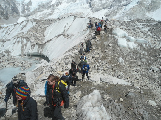
Gorakshep is like the Himalayan version of Grand Central Station. People are either using it as a brief resting spot before trekking straight to Everest Base Camp or overnighting here either because they will set off of Everest Base Camp the following the day. Some have just returned from Base Camp and are doing the reverse. Yaks are coming and going with tons of gear and supplies for expedition preparations. Helicopters are zipping in and out – some carrying scenic flight passengers who prefer to see the region by air, while others are being emergency airlifted out of the areas and back down to lower altitude.
As was reported there are still a few more adventures to come…. I expect one of those will be EBC and probably some more iconic places.

Though, just a few days ago it was reported how some moron defaced the iconic rock at EBC 😣


Very disrespectful!
33 notes
·
View notes
Text


Instagram samheughan
P1:
Helicopter flight from Kathmandu, first sight of the high mountains and Everest in the distance.
We land in the heart of Mahakulung, home to the Kulung Rai. Most of our team are from there, speaking their own language (one of over a hundred different languages spoken in Nepal!).
Honoured to be the first official trekkers to do the "Mahakulung Muddhi-Kongma Dingma Trail"!
Local school and dignitaries blessed us before we set out, aiming for the Amphu Laptsa pass (at 19,200ft) and Everest Base Camp beyond....
But first many miles and feet to climb. Camping along the way, we set out from Chheskam - the literal end of the road, a two day drive from Kathmandu. Passing through jungle and bamboo forest, we had no idea the weather was about to change further up the valley....
Posted 19 December 2024
Pictures 2/2
36 notes
·
View notes
Text

There’s a character to the alpine world that is perhaps indescribable, a tenor to the air and sky and wind and light that permeates everything in such a way that it defies words, defies any attempt at pinning it down in mere words. It is a feeling, an immutable presence enveloping everyone and everything, pressing down upon not in a negative, but in a profoundly positive way, a way that reminds without any pretense subtlety that we humans are but tiny specks, simple visitors to this wild realm, creatures of such little consequence to the magnificence and omnipotence of the surrounding vastness that we might as well not even be there.

And yet there we were, awestruck.
Leaving the windswept hamlet of Kongme Dingma, our team entered into that world immediately. A short climb from the valley brought brought us to panoramic views of the high peaks: Chamlang (the ever present), Kali Himal (AKA Chota Ri), Baruntse, and far in the distance, the imposing South Faces of Lhotse and Nuptse with Everest peeking out just above. Stunning.
From here upward, the Upper Hunku Valley is reminiscent of Khumbu - broad valleys and rushing water flanked on all sides by impossibly high, jagged massifs - but with one huge difference: no people. Up here, unlike Khumbu, there are no villages, no lodges, no trekkers or helicopters, no cell service. In the high Hunku it was as it had been for days before: just us.

We had three days in the upper valley, following a faint-but-solid trail that meandered along the turquoise Hunku; its glacial waters - beginning in the lakes of Seto and Paanch Pokhari - carry fine sediments ground out of the high peaks, sediments so tiny (just a few microns in diameter) they remain suspended in the water, absorbing most blue light and reflecting back the natural green of the water (with some blue) - plus the natural sunlight - creating an otherworldly vividness in this stark world.
With each step upward, altitude records continued to be set for Sam and Jhanak, and new view emerged for us all. Here a peek of Makalu, there a new aspect of Kangtega, Peak 41, Chamlang, or any of the countless unnamed jags of the valley. The toils of altitude, the panting lungs and burning legs, all dissipate under the spell of the high country.
Eventually we made it to our final camp, a beautiful scree shoulder above the upper Paanch Pokhari (paanch means five, and pokhari means pond or small lake) and just below Kami Himal/Chota Ri and the Amphu Laptsa. The December cold set upon us quickly, so we made it a brief evening with heartfelt goodbyes to most of our team: going over the pass would only be Sam, Jhanak, Tshering, Harka, and I along with three porters, Manbir Rai, Hem Rai, and Septa Rai, while the rest would trek together back to Chheskam.

The team at dawn: Jhanak Karki, Sam Heughan, Tshering Dorje Sherpa, and Harka

Sam Heughan moving up high on the south side of the Amphu Laptsa

Sam Heughan making his way up the Amphu Laptsa at about 18,900 feet.
A short night with a full moon found us awake at 5:30 AM ready to begin the climb. It’s not a long one up to the Amphu Laptsa - an ascent of just 1,200 feet - but that is compounded by the altitude plus a technical descent and long walk on the other side making for a solid day. And, a primary rule of the mountains is to always leave a window of daylight just in case: hence, an early start.
From camp, the route up the Amphu is interesting, but never desperate or dangerous. Steep slabs offer significant exposure, but are well-protected by via ferrata-style fixed lines added in recent years. After about 1.5 hours, we crested the prayer-flag crowned top and allowed ourselves time to savor the hard-earned view. From the Amphu, the landscape seems of a dream, and unreal mosaic of spires and walls, glaciers and lakes, blue skies and solitude forever. As I always do, I placed a few kathas at the highest point, offerings of blessings and remembrance for my family, my friends, for humanity, for our world, uttered a silent prayer to any divine presence nearby, and returned to our group a couple dozen feet below.
It was then that a problem arose. I’d like to say it was someone else’s, but ultimately as leader the bock stops with me, so it was mine, and I own it. During trip planning, I had insisted that all members planning to cross the Amphu - and especially any porters - must have traction devices (crampons or microspikes) at minimum. While mountain-hardy and well-heeled, our porters Manbir, Hem, and Septa are still of course human, prone to error and missteps. And, on the descent from the Amphu, an error or misstep will quite quickly lead to a cartwheeling 1,200 foot fall to the valley below. In short, death.

Obviously not a possibility I was willing to even entertain, so I was more than surprised to look down and see them beginning to descend fixed lines without any traction, only Chinese sneakers on polished snow and ice. Yikes.
After letting my stomach stop flip-flopping for a moment, I quickly put on my crampons and rushed down to our porters, our friends, and began making the situation right. There was no way to magically make traction devices appear, so I did what was my only option: made them drop their loads - I’d shuttle the gear to safety - and help them descend safely, chopping out steps where needed, having them stand on my boots when necessary, and hold on to both me and the fixed ropes for safety. It was a long and tedious process taking the better part of 1.5 hours (along with lowering the loads down a particularly steep section with help from Tshering and Harka), but eventually we got it done.

As another twist, in my haste to ensure the porters were safe, I had left Sam and Jhanak atop the pass with no more than a Schwarzenegger-esque “I’ll be back” to keep them safely in place. Fortunately, I know both of them well enough to know they’d be fine: the top of the pass is safe, the skies were clear, and both are level-headed people. Sure enough, when I got back up, they were concerned, but no worse for wear. We began the descent, with both Sam and Jhanak making it look like second nature, clipping fixed lines, rappelling steep slopes, and using crampons and technical equipment without issue.

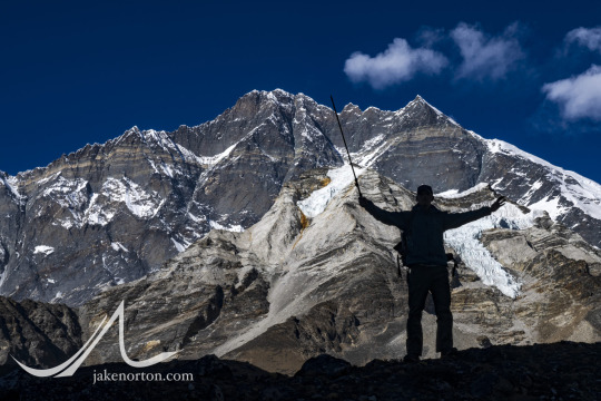
Sam celebrating and silhouetted against the South Face of Lhotse (and a barely discernable Imjatse).
With a sigh of relief, we reached the valley floor - all eight of us - a couple hours later, all in one piece. The hazard was behind, the stress abated, and all we had left was a 6-mile stroll through mesmerizing country to the village of Chukhung and our first roof and bed in 10 days. This last bit was uneventful-but-sublime, softening light warming the massif of the Lhotse-Nuptse wall as we strolled, alone, down valley.
We’d now shifted gears in a big way, we’d left the solitude and remoteness of the Hunku for the relative modernity and front-country-ness of the Khumbu. I won’t say it was bad - I’ve made many a trip up the Khumbu since my first in 1993, and it’s always wonderful, always showing its charms. But, after being utterly immersed in a landscape for some time with no distractions, nothing but us and the mountains, sky, and wind, it was more than a bit jarring for us all to reenter the world once again, phones pinging and helis overhead.
To be honest, there’s not much to share about our journey from Chukhung to Gorak Shep that hasn’t been written about before. We trekked Chukhung to Lobuche, then Lobuche to Gorak Shep, all under the watchful eye of the high peaks. Once at Gorak Shep, we had a bit of food and geared up to watch a ferociously cold sunset from the top of Kala Pattar, the quasi-peak that fins off of Pumori and gives one of the better vantage points of Everest.
The hike up Kala Pattar was again uneventful, it being a simple trail going up about an hour to a rocky bit at 18,450 feet. Once there, we tucked into some rocks to shield from the wind, and prepared to watch the nature’s fireworks light up the sky. While certainly cold, we took the edge off with some of Sam’s special Scottish treats: shortbread and sweets, and of course a dram of Sassenach whiskey to make it all complete. And, the mountain obliged: From Kala Pattar, the upper Southwest Face of Everest is uniquely visible between Nuptse and the West Shoulder, and being the highest, it stays lit by the setting sun after everything else has gone dark. We sat and watched, largely in silence aside from our shivers, as shadows danced pirouettes across the landscape and the world made a slow fade from whites to amber hues, then to vivid reds and oranges, eventually dipping to the cold, dark blue of twilight.
youtube
Under the stars, under the quiet of the Himalayan night, we made our descent.
MOUNTAINS & ADVENTURE, TRAVEL
Everest, Hunku Khola, Muddhi-Kongme Dingma Trail

#JakeNorton #Everest #climber #writer #Nepal #photographer #filmmaker #HunkuValley
Posted 16th January 2025
12 notes
·
View notes
Text

Amphu Laptsa Pass: Linking the Everest and Makalu regions, the Amphu Laptsa Pass is a #challenging and technical #mountain pass that demands mountaineering skills. This pass sits at an #altitude of approximately 5845 meters and is renowned for its #breathtaking #beauty and technical difficulties.
1 note
·
View note
Text
Mera Peak (6475 m) and Island Peak (6189 m) Climbing
Mera Peak (6475 m) and Island Peak (6189 m) Climbing are most challenging adventure destination and popular two peaks climbing routes in the Everest Region of Nepal. You will climb two famous peaks namely Mera Peak (6475 m) and Island Peak (6189 m). Mera and Island Peaks.Also provide a chance to cross remote and outstanding Amphu Laptsa Pass (5,775 m). This trekking and climbing routes are really challenging tea-house and tent camp treks required physical fit travelers. Mera Peak is located on northeast side of Lukla, where the trekking trails through towards Chutanga, Thanganag and Khare camp.
Both peaks are awesome chance to ascend on the top and see the close geographical Hinku valley with massive peak include Mt. Makalu, Mt Kanchenjunga and Mt Cho-You. Mera Peak Climbing offers to you wonderful panoramic views of Langtang Region in the west and Kanchenjunga in the east.
After Mera Peak Climbing, you will continue trek to Island Peak Base camp through Mt. Barunche Base camp and cross the Amphu Laptse Pass to get Island Peak Base camp. Island Peak is standing on front of massive Lhotse Glacier near the south part of Mt. Nuptse. After attempt the Island Peak, you will enjoy with magnificent views of Mt. Makalu Lhotse and many snow-peaks mountains.
We (High Pass Adventure) organized and arranged many trip to Mera and Island Peak Climbing because we have a best team of professional local trekking and climbing Guides and strong Porters to makes memorable trip in your life time.
#islandpeakclimbing#island peak climbing#merapeakclimbing#mera peak climbing#mera peak trek#meraandislandpeakclimbing#everestregion#EverestRegionTrekking#amphu laptsa pass#high pass trek#Highpassadventure#highpassadventuretrek#trekking#climbing#Photography#wonderful vacation#vacation#budget travel#budgettreks#travel#travel and tourism
3 notes
·
View notes
Link

Makalu High Pass Trek
Makalu Trek
Makalu Sherpani col Trek
Makalu via Amphu Laptsa La Pass
Makalu Base Camp Via sherpani col and Amphu Laptsa la pass
Makalu high pass trekking
Makalu Base camp
#Makalu High Pass Trek#Makalu Trek#Makalu Sherpani col Trek#Makalu via Amphu Laptsa La Pass#Makalu Base Camp Via sherpani col and Amphu Laptsa la pass#Makalu high pass trekking#Makalu Base camp
0 notes
Text
Mera Peak (6,476m) and Island Peak (6,189m) via Amphu Laptsa Pass-26 Days

Mera and Island are two famous trekking peaks in the Himalayas for breathtaking panoramic views of five of top ten world’s highest 8,000m mountains on earth; Everest, Lhotse, Kanchanjunga, Makalu and Cho-Oyu, Climbing the Mera and Island peaks combined with crossing the high spectacular and challenging Amphu Lapcha pass makes this expedition a very special one.Resulting the summit of these two trekking peaks over 6000 meter is achievable goal.Further more the trek through the remote valleys of Hinku and Imja tse in Everest region. Great opportunity not to miss this trek in Himalayas.

Detailed Itinerary:
Day 01: Kathmandu:
Upon your arrival at the Tribhuvan intl. airport our representative from mountain sun valley treks welcomes you and assists to transfer in your hotel in Kathmandu. Overnight in Kathmandu.
Day 02: Kathmandu valley sightseeing & trek preparation:
Today,we will head on for our relaxing guided day trip to world heritage sites in Kathmandu valley and visit the highlights of Kathmandu and the surrounding areas. Overnight in Kathmandu.
Day 03: Fly to Lukla, trek to Paiya / Chutok (2,730m):
We took adventurous 24 minutes flight to Lukla. We then head eastwards from Lukla. The trail crisscrosses through pristine hamlets and thick forest along Kalo Himal Ridge. We walk on a jungle trail, cross a bridge over the Handi Khola and reach Surke Village. From here we continue moving south and cross the Chutok La pass before reaching the small settlement of Paiyan, also known as Chutok. Overnight in Paiya.
Day 04: Paiya to Panggom (2,846m):
We descend for a while and reach a small bridge. From here the trail is slippery until we cross the Kari La pass. We walk through rhododendron and bamboo forests on a narrow mountain trail. On today’s trip we also get to be in awe of the Dudhkoshi Valley. We continue our trek to Panggom Village whose settlers are dependent on farming and trading. Overnight in Panggom.
Day 05: Panggom to Ningsow (2,863m):
We begin our trek to Ningsow. After trekking out of Panggom, we cross the Panggom La pass. Then we ascend, walk on a steady path and turn north. We cross Peseng Kharka Khola first then after walking for sometime, we reach Peeng Kharka Danda. We cross Ningsow Khola (stream) before reaching the Ningsow Village. Overnight in Ningsow.
Day 06: Ningsow to Chhatra Khola (2,800m):
From Ningsow,we climb first then descend for a while and climb some more to reach Ramailo Danda. From here we get extraordinary views of Mera Peak and Salpa. After ascending and descending on our trail, we enter the Makalu Barun National Park. Our trail from here to Chhatra Khola is called Pasang Lhamu trail. Overnight in Chhatra Khola.
Day 07: Chhatra Khola to Kothe (3,690m):
After breakfast we walk towards the north on the main trail to Mera Peak. After walking on a trail next to the the Majang Khola, we merge with another trail which moves alongside the Hinku Khola. Our trail moves straight ahead towards Tashing Ongma. We continue our trek and cross the bridge over the Sanu Khola before reaching Kothe. Overnight in Kothe.
Day 08: Trek to Thangnak (4,350m):
As we head to the west bank of the Hinku Khola northwards, forest blurs in and valley zooms out.After several ascents for 4-6 hours,we approach summer settlement of Tangnag as we cross a single-plank bridge at Gondishung. Overnight in Thangnak.
Day 09: Trek to Khare (5,000m):
Approximately 3 hours walk through the lateral moraine of Dig Glacier to Dig Kharka, which offers spectacular views of Charpate Himal. The trail climbs through moraines and to the snout of the Hinku Nup and Shar Glaciers and then climbs more steeply to our camping spot at Khare. The camping experience at Khare is something that would cherish us throughout our life. It is pleasure to view beautiful North face of Mera Peak from our campsite at Khare. Overnight at Khare.
Day 10: Acclimatization day in Khare (5,000m):
After breakfast we begin pre-climb training. Our professional climbing guide will provide training on peak climbing techniques and the proper ways of using climbing gears such as the ice axe, climbing boots and harness, crampons, ascender. The training will also include using ropes to go up and down. Although it is not required to have prior training for Mera Peak Climbing, we believe that some training experience will increase your confidence and climbing skills to increase the chances of scaling the summit as well as to fully enjoy the experience. We can spend rest of the day walking around or resting for the next days big climb. Overnight in Khare.
Day 11: Trek to Mera Base Camp (5,416m):
Today after breakfast, We have to walk through steep route (about 260 meters) and it takes around 3-4 hours to reach Base Camp. Upon reaching there after a short rest accompanied with our lunch, we start ice climbing training with our climbing guide. However, as we will be taking the route to High Camp through Mera La the next day, we might opt to rest at our camp at Base camp today admiring the eye-catching views the area offers. Overnight at Tented camp.
Day 12: Climb to High camp (5,850m):
We need to walk through rock-strewn area for about two hours to make our way to Mera High Camp. The trail can be hazardous if it has recently snowed as there are a number of crevasses here. We make our way to the top of the rock band, which is marked by a large cairn. We set up a high camp and from here the sunrise and sunset can be view along with the Mt. Everest Makalu, Cho Oyu, and south face of Lotshe, Nuptse, Chamlang and Baruntse are outstanding and seems like they are piercing the skyline.Overnight in High Camp.
Day 13: Mera High camp to Mera Peak Summit (6,476m] to Kongme Dingma (4,800m):
Early in the morning at around 2am after breakfast, we advance towards the summit. The group puts on crampons and rope and set up for special journey to the summit. Approximately 6/7 hours walk will take you to the summit of Mount Mera. The view from the summit, can be seen the spectacular panorama including Mt. Everest (8,848m), Kangchenjunga (8,586m), Makalu (8,463m), Lhotse (8,516m), Cho-Oyu (8,210m), Nuptse (7,855m), Chamlang (7,319m), Baruntse (7 ,129m) Ama Dablam (6,812m) Kangtega (6,779m) and many peaks over six thousands meter. After achieving the summit, we retrace our steps down to high camp, where we rest for a while before descending to Kongma Dingma. Overnight in Kongma Dingma.
Day 14: Reserve Day:
We have allocated an extra day as a spare day in case of problems with the weather or acclimatization. Overnight in Tented Camp.
Day 15: Kongma Dingma to Seto Pokhara (5,035m) via Honku Valley:
After a successful expedition to Mera peak, we walk today through the remote valley of the upper yak pastures of this. Throughout the route, we will enjoy panoramic views of the Himalayan valley. It is almost a shock to realize that the two majestic mountains we are heading straight towards are none other than Everest and Lhotse. Overnight in Seto Pokhari.
Day 16: Seto Pokhari to Amphu Lapcha Base Camp through south (5,650m):
Trek through the remote parts of high altitude Himalayas to reach Amphu Laptsa base camp. This route is off the beaten trail, rarely we meet some other trekkers even in high touristic season. We steeply ascend just beyond White Lake, the first of a series of lakes that occupy the upper Honku Basin. Experience the wilderness of the Honku Valley. On the right is Chamlang (7,321m) with hanging glaciers on its South-West and North-West faces, the Honku Valley is true mountain wilderness. Overnight in Amphu Laptsa Base Camp.
Day 17: Amphu Labcha Base Camp to Island peak Base Camp (4,970m):
We cross the Amphu Labcha La pass (5,845m) then walk across the Amphu Labcha Glacier. Lhotse Shar Glacier and Imja Glacier are nearby. Our trail also half circles the Imja Tsho lake before walking on the main Island Peak Base Camp. Overnight in Base Camp.
Day 18: Pre climbing training and preparation day for the summit.
After breakfast we begin pre-climb training. Our professional climbing guide will provide training on peak climbing techniques and the proper ways of using climbing gears such as the ice axe, climbing boots and harness, crampons, ascender. The training will also include using ropes to go up and down. Although it is not required to have prior training for Island Peak Climbing, we believe that some training experience will increase your confidence and climbing skills to increase the chances of scaling the summit as well as to fully enjoy the experience. We can spend rest of the day walking around or resting for the next days big climb. Overnight at Tented camp.
Day 19: High Camp to Island peak (6,189 m) & back to Base Camp (4,970 m):
Today is the big day you are looking for in the whole trip. We wake up around 1 am and take hot tea/coffee and breakfast. After short easy walk trail hit steep climb to the high camp. After the high camp we climb the rocky path then following snow path to the summit glacier. The guide fix a rope when and where it is required. While climbing through the rocky and glacier path fixed rope and man rope both will be used for safety. There are two newely formed crevasses where will be using ladders to cross them. After enjoying summit views and taking breathtaking pictures we descend to the base camp. Overnight at tented camp.
Day 20: Reserve Day:
We have allocated an extra day as a spare day in case of problems with the weather or acclimatization. Overnight in Tented Camp.
Day 21: Island Peak Base Camp to Pangboche (3,800m):
We begin our descent to Pangboche after breakfast. We reach a sparse settlement Chhukung, Dingboche and cross a bridge over the Imja Khola. Our trail passes through beautiful villages, grasslands and cross several bridges before reaching Pangboche. There is an amazing view point a little further from our trail at Dingboche. Overnight in Pangboche.
Day 22: Pangboche to Namche Bazaar (3,440m):
After breakfast we walk to Namche via Tengboche, we can visit the Tengboche Monastery. After we visit monastery in Tengboche trail follow steep descent and leads us back along the Dudh Kosi river. We keep a lookout for wild life such as mountain goats, snow leopards, colorful pheasants, etc, while we pass through the forest by the trail. After passing a Chorten, we reach the army camp at of Namche Bazaar where we want to take a long last look back to Lhotse, the tip of Everest and Tengboche. Overnight in Namche Bazaar.
Day 23: Namche Bazzar – Lukla: (2,800m):
This will be our last day on the trekking trails and it will be a long but rewarding day as we make a return down the DudhKosi valley. From this direction, the views will be entirely different. Eventually, we reach the large town of Lukla with airport where tomorrow we will have a flight back to Kathmandu. Overnight at Lukla Lodge.
Day 24: Fly back to Kathmandu:
The flights to Kathmandu are usually scheduled for morning due to safety reasons. After reaching the capital city, we have the rest of the day off to past the time. We could take a rest in our hotel room or shop for souvenirs for our loved ones. Overnight in Kathmandu.
Day 25: Free day in Kathmandu:
Free day in Kathmandu. Overnight in Kathmandu.
Day 26: Final Departure to home country:
We really hope that you have enjoyed the trekking holiday in Nepal’s majestic hills with us.our representative will accompany you by private vehicle to the international airport for your final departure.
Note: The package can be redesigned or redeveloped as per your preference. For more information please e-mail us at [email protected]
whatsapp: +977 9841815039
#island peak climbing with ebc#mera peak high camp#amphu lapcha pass#mera peak trek#island peak climbing#mera peak island peak and the amphu labtsa#Mera Peak and Island Peak via Amphu Laptsa Pass
0 notes
Text

#Challengingtrek#Hardesttrekintheworld#mostdifficulttrek#redreachhimalayatrek#mostdemandingtrek#notforfainthearted#sherpanicoltrek#amphulaptsatrek#makalubasecamptrek#Baruntsebasecamptrek
0 notes
Text

Makalu base camp, and Sherpani Col trek is one of the great chance to explore the less beaten trails of Makalu region, in the Himalaya which is combined with the popular Everest Region. The wonderful Makalu- Barun National Park gives a speculator views of top landscapes and stunning views surrounding the Mountains. This park is inhabited with extinctive flora fauna, animals (snow leopard and red pandas), different beautiful birds and greenery vegetation. Near by the park you can also observe villages of the ethnic groups of Nepal, Sherpa and Rai community. You will also learn the socio cultural and living styles of Rai and Sherpa people of Himalaya.
This trek includes the crossing of three challenging passes- Sherpani Col 6180m, West Col 6190m and Amphu Laptsa Pass 5850m. These three passes are known as the highest and toughest passes of the whole Himalayan Region in Nepal. Hence, your previous experience of your trekking is highly recommended for the Makalu trek.
Makalu Trek with Sherpani Col having together with Himalaya tourism begins with a flight from KTM to Tumlingtar. While having a flight you can fully enjoy the beautiful scenario from the window seat. After landing in the Tumlingtar airport, we have to take two hours’ drive to reach Khadbari (headquarter of Sankhuwasabha district)- is the starting point of trek. This mountain districts are the most beautiful places in eastern Nepal. We start our hike passing through the terraced fields of hill, green forests of mountain, colorful Rhododendron (national flower of Nepal). Hiking mostly the up and down Hills our track leads us towards Makalu Base Camp.
0 notes
Text
Exploring the Hunku - By Jake Norton (part 2)

When you find a field of sunpati, enjoy it!

Peak 41 rises sharply above Kongme Dingma.
Winds abated, and we spent a stunning day alternating between rest and relaxation, fueling up with copious water and calories, handwashing clothes in icy streams and ourselves as well if we could stand it. Sam, Tshering, and I also spent a couple hours playing on a nearby ice flow, fixing a rope and practicing Sam’s technique with crampons and ice ax, ascending a line and rappelling the same. As expected, he was a natural, making it all seem like old hat, cruising up and down with a smile and confidence seasoned precisely with the right amount of fear and respect for the terrain waiting days ahead on the Amphu Laptsa.
And with that, Part 1 of our trek - the new trail from Chheskam to Kongme Dingma, the Mahakulung Muddhi-Kongmedingma Trail - was finished. The next day we’d enter the alpine, trekking along an established, but seldom used, trail through alpine lakes under serrated behemoths, then up and over the high Amphu Laptsa pass and into the Khumbu. The days before were, as I’d hoped, spectacular, replete with everything a trek in the Himalaya can deliver (but often does not): scenery, solitude, adventure, great company, and memories galore. And, of course, some exploration.

Moonrise over Chamlang from Kongme Dingma.
As mentioned above, we didn’t chart new territory, make a daring first ascent, or add new data to the geographic lexicon. But, we did explore, all of us. We explored areas that were new to us, new to most. We explored new ways to help the villages of Mahalulung - and the thousands of souls who live there - develop and establish sustainable trekking and the income that goes with it. And, perhaps most saliently, we explored ourselves, pushing our own boundaries even just a little, probing the possible, exiting comfort zones and finding joy through hardship, toil, laughter, and camaraderie. Like TS Eliot wrote in Little Gidding back in the last century, an ode less to Magellanic exploration and more to that of the personal:
We shall not cease from exploration And the end of all our exploring Will be to arrive where we started And know the place for the first time. Through the unknown, remembered gate When the last of earth left to discover Is that which was the beginning… - TS Eliot, Little Gidding excerpt from "Four Quartets"
Stay tuned for Part 3 of this story - the Hunku alpine zone, Amphu Laptsa, and Khumbu - coming soon.
(see part 1 of this article here)
44 notes
·
View notes
Text


Instagram samheughan
P1:
Helicopter flight from Kathmandu, first sight of the high mountains and Everest in the distance.
We land in the heart of Mahakulung, home to the Kulung Rai. Most of our team are from there, speaking their own language (one of over a hundred different languages spoken in Nepal!).
Honoured to be the first official trekkers to do the "Mahakulung Muddhi-Kongma Dingma Trail"!
Local school and dignitaries blessed us before we set out, aiming for the Amphu Laptsa pass (at 19,200ft) and Everest Base Camp beyond....
But first many miles and feet to climb. Camping along the way, we set out from Chheskam - the literal end of the road, a two day drive from Kathmandu. Passing through jungle and bamboo forest, we had no idea the weather was about to change further up the valley....
Posted 19 December 2024
Pictures 1/2
19 notes
·
View notes
Text

SH - IG
After the trip. SH updated the initial steps of his itinerary.
Helicopter flight from Kathmandu, first sight of the high mountains and Everest in the distance.
We land in the heart of Mahakulung, home to the Kulung Rai. Most of our team are from there, speaking their own language (one of over a hundred different languages spoken in Nepal!).
Honoured to be the first official trekkers to do the
"Mahakulung Muddhi-Kongma Dingma Trail"!
Local school and dignitaries blessed us before we set out, aiming for the Amphu Laptsa pass (at 19,200ft) and Everest Base Camp beyond....
But first many miles and feet to climb. Camping along the way, we set out from Chheskam - the literal end of through, angie dad brime ro torest, we had. poisia the weather was about to change further up the valley....
@samheughan P1:


You will see many porters on the trails of Nepal carrying heavy loads uphill. In this photo, @mountainworld is attempting to do that - not SH.


Posted 19th December 2024
1 note
·
View note
Text
Tukuche Peak trekking
The Tukuche Peak is situated in the western Nepal Himalayas between the Annapurna and Dhaulagiri Ranges. Albeit moderately less investigated, Tukuche is one of most extraordinary mountain move in Nepal. In spite of being a specialized trip, it's in any case a most loved preparing mountain even among the imminent 8,000er climbers. The pinnacle lies north of the outlandish Hidden Valley. The summit of Tukuche Peak Climbing likewise offers incredible vistas of the encompassing Himalayas including the Annapurna Ranges, Nilgiri and furthermore of the adjacent towns, for example, Marpha and Jomsom.
Our Tukuche Peak Expedition starts with flights from Kathmandu to Pokhara and Pokhara to Jomsom. From Jomsom, we head west to the Marpha town, Yak Kharka, Hidden Valley, and Tukuche Base Camp. After appropriate acclimatization and preparing, we summit the Tukuche Peak Tour and return through a similar course. From Jomsom, we make an arrival trip to Pokhara and afterward to Kathmandu
Tukuche Peak Mountaineering a magnificent mountain situated before Dhaulagiri I and Annapurna run on the opposite side partitioned by the incomparable Kali Gandaki George. This Peak is on the northern side of Nepal in the most out of control valley (shrouded valley) known as Mustang. Kali Gandaki River streams on its base. The Summit of Tukuche Peak offers staggering mountain vistas including whole Annapurna Range, Nilgiri and the delightful towns of Marpha, Syang, and Jomsom.

We endeavor the summit of Tukuche Peak (6920m) around 4/5 days planning in its Base Camp and High Camp by means of North East Ridge. Before endeavoring for climbing Tukuche Peak, the trek toward the pinnacle made through the most profound George of Kali Gandaki utilizing Pokhara-Beni remarkable drive and Tatopani (the hot spring)- Ghasa-Tukuche trekking trail of Annapurna protection territory. Brilliant mountain sees and valleys saw amid the trekking and Peak ascending. Tukuche initially move by a Swiss Team in 1969. Because of its remote area and the reality of the landscape the territory only sometimes visited by business trekking and climbing gatherings. The Tukuche Peak is in Low Category in the feeling of Risk and Technicality.
The endeavor of the summit for this Tukuche Peak Trek starts after we reach in the Hidden Valley Base Camp. When we set up Base Camp we will start pushing out the course and acclimatizing. At the point when the climbing stage is finished, we will drop to Jomsom have a rest there a night or two and take a trip out to Pokhara and afterward on to Kathmandu using any and all means.
Wonderful mountain perspectives and valley will be seen amid the trek and from Tukuche endeavor. After climb up to Tukuche crest you can see a lot of mountain ranges, for example, Annapurna Ranges, Tilicho top, Mt. Nilgiri and furthermore excellent Thakali towns of Marpha, Tukuche Village, Syang and Jomsom Valley. The voyage arrived at end at Jomsom and afterward fly back to Pokhara and evenng trip to Kathmandu. This endeavor is viewed as low unsafe yet specialized solo campaign. Along these lines, typically a large portion of climber make their own specific manner utilizing just elevated style setting camp 1 and camp 2 (6,100m.) by means of North West edge to get the summit of Tukuche Peak.

The course to Tukuche Peak Trekking trails through the great Annapurna at last getting away from Marpah town to the Yak Kharka and Tukuche Base Camp. The Tukuche Peak Climb starts with flights from Kathmandu to Pokhara and after that Pokhara to Jomsom. From Jomsom, we will travel west to the Marpha town, Yak Kharka, Hidden Valley, and afterward Tukuche Base Camp. When we set up base camp, we will start pushing out the course and acclimatizing. At that point after appropriate acclimatization, we summit the Tukuche Peak and return by means of a similar course. Tukuche right off the bat mounted by a Swiss Team in 1969 and there were absolute 38 undertakings that were endeavored to move till 2007. Because of the remote area and the importance of the territory the region is infrequently visited by business trekking and climbing gatherings. Amid the trek to Tukuche, we will get an opportunity to cross a portion of the goes as Thapa Pass, French Pass, Italian Base Camp and Dhaulagiri Base Camp.
The voyage to the pinnacle is encouraged for around 4/5 days of arrangement in the base camp and high camps in the North-East Ridge. The trek towards the pinnacle is produced using the most profound valley of Kali Gandaki through a Pokhara-Beni drive. On the way, Tatopani is situated alongside the trekking trail of Ghasa Tukuche of the Annapurna preservation zone. The street is loaded up with the grand mountain sees and valleys all through the whole trekking voyage.
The stroll to the Tukuche Peak Mountaineering Tour is started in the wake of achieving the Hidden Valley base camp. Through the base camp, we will have a time of acclimatization so as to adjust to the elevation. When the climbing stage is finished, there will drop Jomsom to have a rest. The resting time frame is described by a couple of days. From that point forward, there will be a trip to Pokhara and continue to Kathmandu.

Tukuche Peak Itinerary requires physical stamina that can be picked up from acclimatization and physical wellness. The summit gives the best perspective on Annapurna Range, Nilgiri notwithstanding Marpha and Jomsom towns. AS the trail heads through the most profound canyon in Nepal, Kaligandaki Gorge, religiously accepted to be the habitation the Lord Shiva. Also, the Shaligram (a fossil stone) that is observed here is accepted to be image of the Lord Vishnu. The refreshment at Tatopani, where we loosen up half-submerged into tepid water at tatopani is Phenomenal. As the route goes through Annapurna Conservation Area, we will go over a verdure aplenty that holds a wide scope of jeopardized types of creatures, winged creatures and plants. The climbing through dry geography of Mustang and Jomsom is ideal experience. The rural neighborliness and convention in the locale have gravity in them.
Abi Peak Climbing Bokta Peak Climbing Parchamo Peak Climbing Mera Peak Amphu Lapcha La Pass Larkya Peak Climbing Phari Laptsa Peak Climbing Nirekha Peak Climbing Mera Peak Climbing Island Peak Climbing
0 notes
Text
Over the Amphu, Into the Khumbu (P1)
Part 3 of Jake Norton's blog

There’s a character to the alpine world that is perhaps indescribable, a tenor to the air and sky and wind and light that permeates everything in such a way that it defies words, defies any attempt at pinning it down in mere words. It is a feeling, an immutable presence enveloping everyone and everything, pressing down upon not in a negative, but in a profoundly positive way, a way that reminds without any pretense subtlety that we humans are but tiny specks, simple visitors to this wild realm, creatures of such little consequence to the magnificence and omnipotence of the surrounding vastness that we might as well not even be there.

Sam Heughan and Jhanak Karki trek through the Upper Hunku Valley near Seto Pokhari.
And yet there we were, awestruck.
Leaving the windswept hamlet of Kongme Dingma, our team entered into that world immediately. A short climb from the valley brought brought us to panoramic views of the high peaks: Chamlang (the ever present), Kali Himal (AKA Chota Ri), Baruntse, and far in the distance, the imposing South Faces of Lhotse and Nuptse with Everest peeking out just above. Stunning.
From here upward, the Upper Hunku Valley is reminiscent of Khumbu - broad valleys and rushing water flanked on all sides by impossibly high, jagged massifs - but with one huge difference: no people. Up here, unlike Khumbu, there are no villages, no lodges, no trekkers or helicopters, no cell service. In the high Hunku it was as it had been for days before: just us.

Jhanak, Aashish, and Sam play some intense Rummy 500 trailside.

Chamlang and camp, Upper Hunku Valley, Nepal.
Seto Pokhari catches the reflection of Lhotse, Nuptse, and Peak 6764.

Hem Rai enjoys the views in the Upper Hunku.

Seto Pokhari and the peaks of the Upper Hunku Valley.

Paanch Pokhari luminous in the Upper Hunku.
We had three days in the upper valley, following a faint-but-solid trail that meandered along the turquoise Hunku; its glacial waters - beginning in the lakes of Seto and Paanch Pokhari - carry fine sediments ground out of the high peaks, sediments so tiny (just a few microns in diameter) they remain suspended in the water, absorbing most blue light and reflecting back the natural green of the water (with some blue) - plus the natural sunlight - creating an otherworldly vividness in this stark world.
With each step upward, altitude records continued to be set for Sam and Jhanak, and new view emerged for us all. Here a peek of Makalu, there a new aspect of Kangtega, Peak 41, Chamlang, or any of the countless unnamed jags of the valley. The toils of altitude, the panting lungs and burning legs, all dissipate under the spell of the high country.
Eventually we made it to our final camp, a beautiful scree shoulder above the upper Paanch Pokhari (paanch means five, and pokhari means pond or small lake) and just below Kami Himal/Chota Ri and the Amphu Laptsa. The December cold set upon us quickly, so we made it a brief evening with heartfelt goodbyes to most of our team: going over the pass would only be Sam, Jhanak, Tshering, Harka, and I along with three porters, Manbir Rai, Hem Rai, and Septa Rai, while the rest would trek together back to Chheskam.

Peak 6764 rises high above the Hunku.
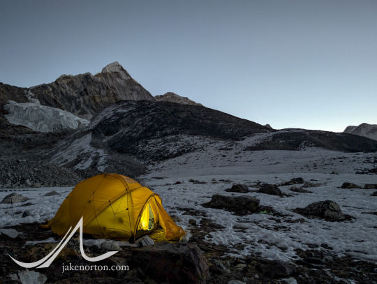
Kali Himal (Chota Ri) stands guard over high camp and Sam's tent in the Hunku

The team at dawn: Jhanak Karki, Sam Heughan, Tshering Dorje Sherpa, and Harka Kulung Rai.

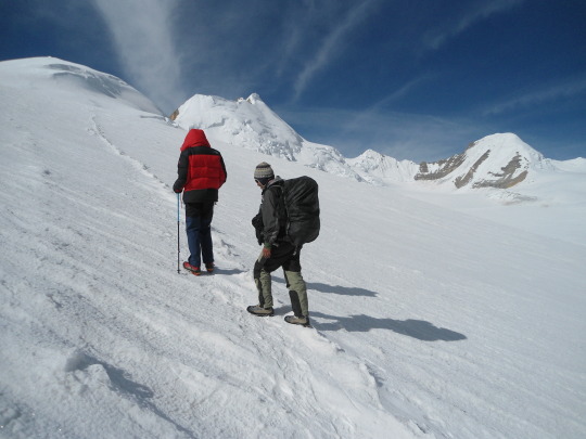
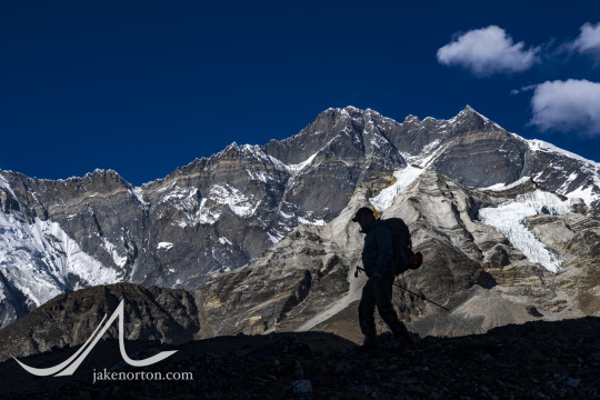
Sam Heughan moving up high on the south side of the Amphu Laptsa.

Panorama from midway up the Amphu Laptsa, looking south down the Hunku Valley.

The wild summit of Peak 41 rises into the blue sky.

Sam Heughan making his way up the Amphu Laptsa at about 18,900 feet.
A short night with a full moon found us awake at 5:30 AM ready to begin the climb. It’s not a long one up to the Amphu Laptsa - an ascent of just 1,200 feet - but that is compounded by the altitude plus a technical descent and long walk on the other side making for a solid day. And, a primary rule of the mountains is to always leave a window of daylight just in case: hence, an early start.
From camp, the route up the Amphu is interesting, but never desperate or dangerous. Steep slabs offer significant exposure, but are well-protected by via ferrata-style fixed lines added in recent years. After about 1.5 hours, we crested the prayer-flag crowned top and allowed ourselves time to savor the hard-earned view. From the Amphu, the landscape seems of a dream, and unreal mosaic of spires and walls, glaciers and lakes, blue skies and solitude forever. As I always do, I placed a few kathas at the highest point, offerings of blessings and remembrance for my family, my friends, for humanity, for our world, uttered a silent prayer to any divine presence nearby, and returned to our group a couple dozen feet below.
It was then that a problem arose. I’d like to say it was someone else’s, but ultimately as leader the bock stops with me, so it was mine, and I own it. During trip planning, I had insisted that all members planning to cross the Amphu - and especially any porters - must have traction devices (crampons or microspikes) at minimum. While mountain-hardy and well-heeled, our porters Manbir, Hem, and Septa are still of course human, prone to error and missteps. And, on the descent from the Amphu, an error or misstep will quite quickly lead to a cartwheeling 1,200 foot fall to the valley below. In short, death.

Sam Heughan atop the Amphu Laptsa, pointing to Everest in the distance.

360-degree panorama from the top of the Amphu Laptsa.

Footprints lead down into the abyss, looking east from the top of the Amphu Laptsa.

A katha I placed on top of the Amphu Laptsa.

Steep slopes on the north side of the Amphu Laptsa.
Jhanak Karki (left) and Sam Heughan (right) high on the Amphu Laptsa Pass in Nepal. Lhotse and Everest are the primary peaks in the background.
Obviously not a possibility I was willing to even entertain, so I was more than surprised to look down and see them beginning to descend fixed lines without any traction, only Chinese sneakers on polished snow and ice. Yikes.
After letting my stomach stop flip-flopping for a moment, I quickly put on my crampons and rushed down to our porters, our friends, and began making the situation right. There was no way to magically make traction devices appear, so I did what was my only option: made them drop their loads - I’d shuttle the gear to safety - and help them descend safely, chopping out steps where needed, having them stand on my boots when necessary, and hold on to both me and the fixed ropes for safety. It was a long and tedious process taking the better part of 1.5 hours (along with lowering the loads down a particularly steep section with help from Tshering and Harka), but eventually we got it done.
Sam Heughan silhouetted against the South Face of Lhotse (and Imjatse barely discernable in the foreground).
As another twist, in my haste to ensure the porters were safe, I had left Sam and Jhanak atop the pass with no more than a Schwarzenegger-esque “I’ll be back” to keep them safely in place. Fortunately, I know both of them well enough to know they’d be fine: the top of the pass is safe, the skies were clear, and both are level-headed people. Sure enough, when I got back up, they were concerned, but no worse for wear. We began the descent, with both Sam and Jhanak making it look like second nature, clipping fixed lines, rappelling steep slopes, and using crampons and technical equipment without issue.
Sam celebrating in the valley above Chukhung.

Amphulaptsa Tsho below the north face of Ama Dablam.

Tawoche and Cholatse in fdaing light above the village of Chukhung.
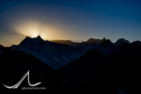
Twilight on the high peaks.
With a sigh of relief, we reached the valley floor - all eight of us - a couple hours later, all in one piece. The hazard was behind, the stress abated, and all we had left was a 6-mile stroll through mesmerizing country to the village of Chukhung and our first roof and bed in 10 days. This last bit was uneventful-but-sublime, softening light warming the massif of the Lhotse-Nuptse wall as we strolled, alone, down valley.
We’d now shifted gears in a big way, we’d left the solitude and remoteness of the Hunku for the relative modernity and front-country-ness of the Khumbu. I won’t say it was bad - I’ve made many a trip up the Khumbu since my first in 1993, and it’s always wonderful, always showing its charms. But, after being utterly immersed in a landscape for some time with no distractions, nothing but us and the mountains, sky, and wind, it was more than a bit jarring for us all to reenter the world once again, phones pinging and helis overhead.

Harka rests at a chorten near Dingboche.

Pack horses rest at memorial chortens for fallen climbers at Memorial Hill above Tukhla.

Our gang!
See part 2 here
36 notes
·
View notes